The territory of Georgia is divided into 9 regions, 1 city, and 2 autonomous republics: Abkhazia and Samatchablo (South Ossetia) These in turn are subdivided into 67 districts and 12 self-governing cities. The 9 regions of Georgia are Guria, Imereti, Kakheti, Kvemo Kartli, Mtskheta-Mtianeti, Racha-Lechkhumi and Kvemo Svaneti, Samegrelo-Zemo Svaneti, Samtskhe-Javakheti, and Shida Kartli. Tbilisi itself is divided into ten districts.

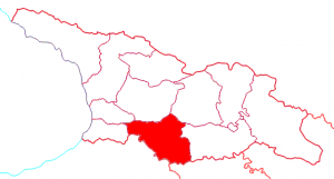
Kartli (8,10)
Sea level: 400 m – 2800 m
Population: 821 900
Cities: Tbilissi, Mtskheta, Gori, Tskhinvali, Kaspi, Khashuri, Rustavi
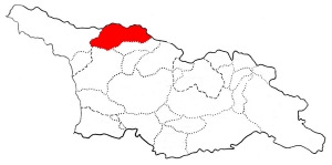
Kartli is a historical region in central-to-eastern Georgia traversed by the river Mtkvari (Kura), on which Georgia’s capital, Tbilisi, is situated. Known to the Classical authors as Iberia, Kartli played a crucial role in the ethnic and political consolidation of the Georgians in the middle Ages. Kartli had no strictly defined boundaries and they significantly fluctuated in the course of history. After the partition of the kingdom of Georgia in the 15th century, Kartli became a separate kingdom with its capital at Tbilisi. The historical lands of Kartli are currently divided among several administrative regions of Georgia. In the Middle Ages, Kartli was traditionally divided, roughly along the Mtkvari, into the three principal regions: Inner Kartli, centered on Mtskheta and Uplistsikhe comprising all of central Kartli north and south of the Mtkvari and west of its tributary, the Aragvi. Lower Kartli, comprising the lands in the lower basin of the Mtkvari and south of that river. Upper Kartli, comprising the lands in the upper basin of the Mtkvari and south of that river, west of Kvemo Kartli. The role of this region was still important for the peace of all Georgia. There are many monasteries, fortresses and rich of nature.
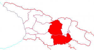
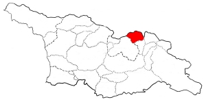
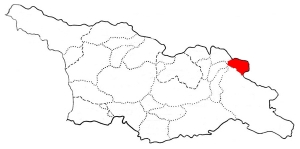
 Kakheti (11)
Sea Level : de 600 m
Population: 403 600
Cities: Telavi, Gurjaani, Kvareli, Sagarejo, Dedoplistskaro, Signagi, Lagodekhi, Akhmeta
Kakheti is formed in eastern Georgia from the historical province of Kakheti and the small, mountainous province of Tusheti. Telavi is its capital. Kakheti is bordered by the Russian Federation to the Northeast, Azerbaijan to the Southeast. The eastern region of Kakheti is Georgia’s premier wine-producing area. Kakheti is also rich in history: here you’ll find the incredible monastery complex of Davit Gareja, the picturesque hilltop town of Sighnaghi, and many beautiful churches, castles and mansions around the main town, Telavi.
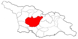 Imereti (6)
Sea Level: 200 m – 2500 m
Population:697 600
Cities: Kutaissi, Zestaphoni, Tskaltubo, Samtredia, Chiatura, Tkibuli, Zestafoni, Vani, Khoni, Sachkhere
The main city of the region is Kutaisi. Imereti is divided into Zemo (upper) and Kvemo (lower) Imereti. It borders the Likhi Mountain Range to the east, Tskhenistskali River to the west, the Caucasus Mountains to the north and Meskheti or Persati Mountains to the south. The lowlands of Imereti are mostly covered with Colchis low brush, forests, oaks, groves, and meadows. The mountainous parts of Imereti are mainly Colchis deciduous forests. The forests of Imereti are rich with animals and birds. The people of Imereti are very hospitable. They are treated to a variety of dishes. Walnuts are widely used in their cuisine, which adds a wonderful flavor to local products. Most Imeretian food is prepared in clay pots and cooked with herbs.
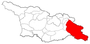
 Samtskhe – Javakheti (7)
Sea level: 300 m – 3 200 m
Population: 208 000
Cities: Akhaltsikhe, Adigeni, Aspindza, Borjomi, Akhalkalaki, Ninotsminda
Samtskhe-Javakheti is a region formed from the historical provinces of Meskheti (Samtskhe), Javakheti and Tori (Borjomi gorge). Akhaltsikhe is its capital. Samtskhe-Javakheti is bordered by the regions of Adjara to the west, Guria and Imereti to the north, Shida Kartli and Kvemo Kartli to the north-east and to the east, and by Armenia and Turkey to the south and southwest. The Baku-Tbilisi-Ceyhan oil pipeline, the South Caucasus natural gas pipeline, and the Kars–Tbilisi–Baku railway pass through the region. The major tourist attractions are the cave monasteries of Vardzia (founded by Queen Tamar in 1185), Vanis Kvabebi (which dates from the 8th century), Rabati Castle and Khertvisi fortress. Also, among national visitors is very popular 10th century Sapara Monastery, Tmogvi fortress, and 8th century Zarzma monastery.
 Ratcha (5)
Sea level: 300 m – 3300 m1
Population: 51 000
Cities: Oni, Ambrolauri
Racha is a highland area in western Georgia, located in the upper Rioni river valley and hemmed in by the Greater Caucasus mountains. Racha occupies 2,854 km2 in the north-eastern corner of western Georgia. Spurs of the Greater Caucasus crest separates Racha from the Georgian historical regions of Svaneti and Lechkhumi on the north-west and from Imereti on the south, while the main Caucasus ridge forms a boundary with Russia’s North Ossetia. On the east, Racha is bordered by breakaway South Ossetia, officially part of Georgia’s Shida Kartli region. The region is famous for its different natural mineral water springs and tourist attractions : Nikortsminda, Barakoni or Chaori lake.
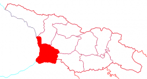 The coastline of Georgia (1,2,3,4)
Sea level: 10 m – 2800 m
Population: 517 800
Cities: Batoumi, Poti, Anaklia, Ureki, Kobuleti
The coastline of Georgia comprises the following regions: Adjara, Guria, Samegrelo. Each region keeps their specificities and offers the palette of different traditions. The Black Sea coast is well known for its humid climate with subtropical nature (especially along the coastal regions) and prolonged rainy weather, although there is plentiful sunshine during the spring and summer months. Compared to “Nice” of France, Batumi becomes the most beautiful city on the Black Sea coast. The botanical garden on the green cape, the boulevard still bustling with bungalows, cafes and discotheques give the city active image.
Abkhazia
Sea level: 10 m – 4000 m
Population: 242 862
Cities: Sukhumi, Gali, Gagra
Abkhazia is a non recognised state on the eastern coast of the Black Sea and the south-western flank of the Caucasus Mountains, south of Russia and northwest of Georgia proper. It covers 8,660 square kilometres (3,340 sq mi) and has a population of around 240,000. Its capital is Sukhumi. The separatist Abkhazian polity, formally the Republic of Abkhazia or Apsny is recognised only by Russia and a small number of other countries. While Georgia lacks control over Abkhazia, the Georgian government, the United Nations and the majority of the world’s governments consider Abkhazia part of Georgia, whose constitution designates the area as the Autonomous Republic of Abkhazia. Abkhazia is richly irrigated by small rivers originating in the Caucasus Mountains. Chief of these are: Kodori, Bzyb, Ghalidzga, and Gumista. The Psou River separates the region from Russia, and the Inguri serves as a boundary between Abkhazia and Georgia proper. There are several periglacial and crater lakes in mountainous Abkhazia. Lake Ritsa is the most important of them. Because of Abkhazia’s proximity to the Black Sea and the shield of the Caucasus Mountains, the region’s climate is very mild. The coastal areas of the republic have a subtropical climate, where the average annual temperature in most regions is around 15 °C (59 °F), and the average January temperature remains above freezing. The lowland regions used to be covered by swaths of oak, beech, and hornbeam, which have since been cleared.
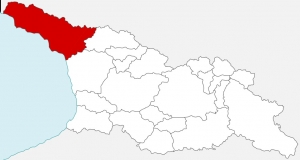
 Svaneti
Sea level: 2200 m.- 5629 m
Population: 26 000
Cities: Mestia, Ushguli
Svaneti is a historic province in Georgia, in the northwestern part of the country. It is inhabited by the Svans, an ethnic subgroup of Georgians. Situated on the southern slopes of the central Caucasus Mountains and surrounded by 3,000–5,000 meter peaks, Svaneti is the highest inhabited area in the Caucasus. Four of the 10 highest peaks of the Caucasus are located in the region. The highest mountain in Georgia, Mount Shkhara at 5,201 meters (17,059 feet), is located in the province. Svaneti has two parts corresponding to two inhabited valleys: Upper Svaneti, Lower Svaneti. Typically bilingual, they use both Georgian and their own, unwritten Svan language, which together with the Georgian, Mingrelian, and Laz languages constitute the South Caucasian or Kartvelian language family. Svanetia is known for their architectural treasures and picturesque landscapes. The botany of Svanetia is legendary among travelers.The famous Svanetian towers erected mainly in the 9th-12th centuries, make the region’s villages more attractive. In the province are dozens of Georgian orthodox churches and various fortified buildings. Architectural monuments of Upper Svanetia are included in a list of UNESCO World Heritage Sites. Svan culture survives most wonderfully in its songs and dances. Svanetia boasts arguably the most archaic three-part polyphonic singing. Most of their songs are connected to round dances, are performed very loud and are full of dissonant chords.
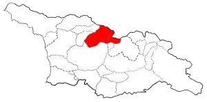
 Khevi (9)
Sea level: 800 m -1720 m
Population: 4 800
Villages: Gudaouri, Stephantsminda, Sno, Djutha
Khevi is a small historical-geographic area in northeastern Georgia. It is included in the modern-day Kazbegi district, Mtskheta-Mtianeti region. Located on the northern slopes of the Greater Caucasus mountains, it comprises three gorges of the rivers Truso, Tergi (Terek) and Snostsq’ali. The landscape of Khevi is dominated by alpine meadows dotted with rhododendron, mountain passes and waterfalls, and the Mount Kazbek (locally known as Mkinvartsveri, i.e. “ice-capped”), a dormant 5047-meter high volcano. The area is a popular tourist destination. It is a part of the projected Khevi-Aragvi Biosphere Reserve. Among the important cultural sites of Khevi are the Gergeti Trinity Church (XIV c), Garbani Church (IX c), Sioni Basilica (X c) and castle, Betlemi Monastery Complex (X c), and Sno fortress.
 Khevsureti (9)
Sea level: 1200 m -1900 m
Population: 3 200
Villages: Barisakho, Chatili, Mutso
Khevsureti is a historical-ethnographic region in eastern Georgia. They are the branch of Kartvelian (Georgian) people located along both the northern and southern slopes of the Great Caucasus Mountains.Their religion is a unique mixture of Georgian Orthodox Christianity and pre-Christian cults. They worship sacred places locally known as jvari (“cross’), khati (“icon”) or salotsavi (“sanctuary”). Aside from their religious character, these were the sites where the locals discussed and decided common matters such as raids against enemies, peace-making, appeals of various characters, etc. Even during the Soviet period, with its harsh restrictions against any religious activities, each year the Georgian highlanders gathered with a group of elder priests and performed their traditional rituals. Like other mountainous areas of Georgia, Khevsureti is characterized by a great diversity of traditions and customs. Khevsurs speak a local dialect of the Georgian language that resembles the literary Georgian of the Middle Ages and retain many of their ancient traditions including elements of folk ritual.The institution of the Blood feud was still alive in the twentieth century. Khevsur music also resembles that of Georgia in the Middle Ages. Khevsureti is famous for its Medieval ballads and folk music. The architecture of Khevsureti is mostly highly fortified and defensive in character,featuring a profusion of towers clinging to the mountainsides,signifying constant vigilance in the face of enemy attack. Dozens of fortifications, sanctuaries and churches are scattered across the province. Chief of these are the Khakhmati fortress, Akhieli fortress, Lebaiskari fortress, Mutso fortress, Shatili fortifications, Gudani Cross, and the Anatori Cross.
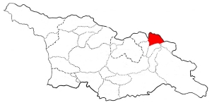
 Tuchethi (11)
Sea level: 1500 m – 3200
Population: 200
Villages: Omalo Dartlo…
Tusheti is an historic region in northeast Georgia. Located on the northern slopes of the Greater Caucasus Mountains, Tusheti is bordered by the Russian republics of Chechnyaand Dagestan to the north and east, respectively; and by the Georgian historic provinces Kakheti and Pshav-Khevsureti to the south and west, respectively. The population of the area is mainly ethnic Georgians called Tushs or Tushetians . Traditionally, the Tushs are sheep herders. Tushetian Guda cheese and high quality wool was famous and was exported to Europe and Russia. Even today sheep and cattle breeding is the leading branch of the economy of highland Tusheti. The local shepherds spend the summer months in the highland areas of Tusheti but live in the lowland villages of Zemo Alvani and Kvemo Alvani in wintertime. Their customs and traditions are similar to those of other eastern Georgian mountaineers. One of the most ecologically unspoiled regions in the Caucasus, Tusheti is a popular mountain-trekking venue.

